
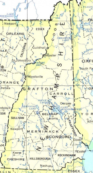
NH State Map
Below is a map of the state of New Hampshire. The map shows the different NH counties and some of the popular towns and cities in NH. The NH state map does not show any NH roads or highways. The map does show the bordering states of Maine, Massachusetts and Vermont as well as Canada to the North of NH on the state map.
The NH state map also includes the following (from North to South): Coos County, Umbagog Lake, Town of Lancaster NH, Moore Reservoir, Town of Woodsville NH, Grafton County, Carroll County, Town of Ossipee NH, Squam Lake, Newfound Lake, Lake Winnipesaukee, Belknap County, Laconia, NH, Sullivan County, Newport NH, Strafford County, Merrimack River, Merrimack County, Concord NH, Dover NH, Exeter NH, Keene NH, Cheshire County, Hillsborough County, Nashua NH, and Rockingham County in New Hampshire.

no-photo
Leave a Question, Comment, or Review
You must be logged in to post a comment.

0 Questions, Comments, and Reviews on “Map of New Hampshire”
Raymond NH?
Location on map?